
 |
|  |
| About the Region
- Home
- /
- About the Region


Southeast region in Republic of Macedonia
Southeast region
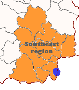
The Southeastern Statistical Region is one of eight statistical regions of the Republic of Macedonia. Southeastern region is located in the southeastern part of the country and it borders with Republic of Greece and Bulgaria. Internally the region borders with the Vardar and Eastern statistical regions.


The current population of the Southeastern Statistical Region is 171,416 citizens, according to the last population census in 2002.
| Census Year | Population | Change |
|---|---|---|
| 1994 | 167,941 | N/A |
| 2002 | 171,416 | +3.13% |
The largest ethnic groups in the region are the Macedonians
| Number | % | |
|---|---|---|
| TOTAL | 171,416 | 100 |
| Macedonians | 154,957 | 90.4 |
| Turks | 12,661 | 7.4 |
| Serbs | 1,194 | 0.7 |
| others | 2,604 | 1.5 |
Blagoevgrad Province
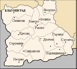
The Blagoevgrad Region is located in the south-western part of the territory of the Republic of Bulgaria. It is situated between the regions of Kyustendil, Sofia, Pazardzhik and Smolyan, and national borders with Greece and Macedonia. The overall area of the region includes the valleys of the rivers Struma and Mesta, the Pirin mountain, and parts of the mountains Rila, Rhodopes, Slavyanka, Belasitsa [mkd. Belasica], Ograzhden [mkd. Ogražden], Maleshevska [mkd. Maleševska] and Vlahina [mkd. Vlaina]. The Blagoevgrad Region is part of the Southwest Planning Region. The region’s territory covers an area of 6,452.3 km2, accounting for 5.8%of the country’s territory. The region is divided in 14 municipalities, 96 districts and 280 settlements. The Blagoevgrad Region has an exceptionally varied relief. The highest mountains in Bulgaria – Rila, Pirin and Rhodopes – are found in this region. Although smaller, the Vlahina, Maleshevska, Ograzhden, Belasitsa and Slavyanka mountains also contribute for the mountainous relief on parts of the region’s territory. The region’s water resources consist of the major drainage arteries of the rivers Struma and Mesta, and their numerous tributaries – Blagoevgradska Bistritsa, Pirinska Bistritsa, Lebnitsa, Strumeshnitsa, Belishka, Demyanitsa, Bistritsa, Tufcha, etc. The climate here is strongly affected by Mediterranean influences along the courses of the rivers Struma, Strumeshnitsa and Mesta. This creates favourable conditions for the cultivation of many Mediterranean plant species that require warm weather. The river valleys allow for good irrigation and melioration. The soil is suitable for the production of tobacco, grapes, fruits, crops that require warm weather, herbs, mushrooms, etc. The region is characterised by long summer droughts in the plains, with precipitation lower than the country’s average, unevenly distributed across the seasons and months. This creates problems, as the need for irrigation increases, which in turn makes the agricultural production more expensive. Furthermore, spring frosts and early autumn frosts can do serious damage to vegetables, tobacco and fruit trees. According to the data from the last census, on 01.02.2011, the population of the Blagoevgrad Region amounted to 323,552 people, or 4.4% of the total population of Bulgaria.
Municipalities of the region
Blagoevgrad
Bansko
Belitsa
Gotse Delchev
Garmen
Kresna
Petrich
Razlog
Sandanski
Satovcha
Simitli
Strumyani
Hadzhidimovo
Yakoruda
Cross-border Partnership for Environmental Protection and Better Quality of Life (Waste EDU)

The web-site is co-funded by EU trough the INTERREG - IPA Cross-border Programme CCI 2014TC16I5CB006 Bulgaria- Macedonia. This web site has been produced with the assistance of the European Union. The contents of this web site are the sole responsibility of the Center for Climate Change- Gevgelija and can in no way be taken to reflect the views of the European Union, the participating countries and the Managing Authority.